

HISTORY
The following history is given on the North Sydney Council website. It will be updated over time to better reflect the input of the community in its inception:
Carradah Park is named after the Cammeraygal man, Carradah, who befriended Lieutenant Lidgbird Ball, after whom nearby Balls Head was named in the 1790s. The Aboriginal man reportedly adopted Ball’s surname as a sign of respect. He was one of the few Cammeraygal people specifically named in the early colonial accounts.
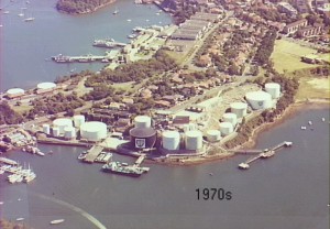
Although no known sites remain, this area would have been used by Aboriginals from the Cammeraygal tribe. The first recorded occupation of the area by Europeans was in 1825 when Edward Wollstonecraft acquired a grant of 524 acres of land. The site was leased to the Anglo-Persian Oil Company Ltd (the predecessor of BP) in 1920, and the first storage tank was built around 1923. The terminal was reduced to minimum operation in 1993, and the fuel storage infrastructure was demolished in 1996.

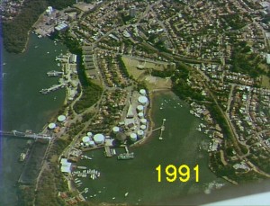
In 1997 the then Premier Bob Carr announced that this site, together with the Coal Loader and Caltex Sites on the western side of the Waverton peninsula would be preserved as Public Open Space. A Strategic Master Plan for the sites was completed in 1999, and construction of the newly-designed park lands was completed in 2005.
FACILITIES


Carradah Park has a web of pathways allowing the old terminal terraces and tank excavations to be explored. Interpretive signage abounds to enable sense to be made of the remaining elements of the old storage and distribution facility. Picnic tables are available on the lower terrace. Public toilets are less than 200m outside the park in Waverton Park.


GETTING THERE
The park wraps around the headland jutting into Berrys Bay which was once known as Gibralter.
On Foot
It is accessible on foot as part of the system of walkways around the foreshore of Sydney Harbour, and follows on from Waverton Park at its northern boundary. Following this path leads around the headland and out of the park via a pedestrian corridor through RMS land to Balls Head Road. Alternatively the park can be accessed on foot from Larkin Street with parks leading to its headland lookout. another path from there leads down via heritage stairs and links to Balls Head Drive.
By Public Transport
The 265 bus has stops in Woolcott Street adjacent to Waverton Park from which access is a mere few hundred metres walk.
The Waverton Railway Station is a few hundred metres further, in Bay Road. By walking down Bay Road, and its extension, Balls Head Road, one is taken to the foot of the hill and two entrances to Carradah Park, one leading along a terrace and up to the lookout whilst the lower connection follows the water.
By Car
Parking is generally available in Balls Head Road or Larkin Street, with the latter providing disabled access to the lookout with its panoramic views of the city.
COUNCIL INFORMATION
For further information on Carradah Park, visit the North Sydney Council website here.